فضاپیمای WorldView-1 توسط آژانس ملی اطلاعات مکانی ایالات متحده آمریکا طراحی و توسعه یافت. ماموریت اصلی این ماهواره تصویربرداری سیاه و سفید با وضوح بالا به منظور اهداف دفاعی و اطلاعاتی، امداد رسانی، نقشه برداری، برنامه ریزی کاربری زمین و شبیه سازی محیط است. سیستم تصویربرداری ماهواره پانکروماتیک (سیاه و سفید) با وضوح نیم متری می باشد. این ماهواره با متوسط زمان بازدید مجدد ۱٫۷ روزه، قابلیت پوشش مکانی بیشتر از ۷۵۰۰۰۰ کیلومتر مربع را در هر روز دارد. WorldView-1در سپتامبر ۲۰۰۷ از پایگاه نیروی هوایی Vandenburg در کالیفرنیا با طول عمر ۷ ساله برنامه ریزی و پرتاب شد. WorldView-1 توسط Ball Aerospace ساخته شده که متعلق به شرکت DigitalGlobe می باشد.

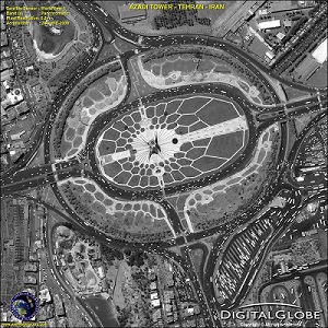
نمونه ای از تصاویر WorldView-1، ایران- برج آزادی تهران، ۲۰۰۹ میلادی
| WorldView-1 Satellite Specifications | |
| Imaging Mode | Panchromatic |
| Sensor Resolution | .۵۰ meter GSD at Nadir ۰٫۵۹ meters GSD at 25° off-nadir |
| Spectral Range | ۴۰۰-۹۰۰ nm |
| Swath Width | ۱۷٫۶ km at nadir |
| Off-Nadir Imaging | ۰-۳۰ degrees off-nadir Higher angles selectively available |
| Dynamic Range | ۱۱-bits per pixel |
| Mission Life | Expected end of life 2018 |
| Revisit Time | ۱٫۷ days at 1 meter GSD or less ۴٫۶ days at 25° off-nadir or less (0.59 meter GSD) |
| Orbital Altitude | ۴۹۶ km |
| Nodal Crossing | ۱۰:۳۰ am |
مطالب مرتبط:
۱. ماموریت و وظایف سنجش از دور سازمان فضایی ایران
۲. معرفی سنجنده های سنجش از دوری/GoeEye-1
۳. سنجشازدور چیست؟
برای کسب اطلاعات بیشتر درباره دوره آموزشی آشنایی با نرم افزارهای پردازش تصاویر راداری (InSAR) به منظور محاسبه تغییر شکل سطحی کلیک کنید.


